Future household predictions based on the latest census data are now possible!
~Future population and household prediction tool version 3 (household prediction implementation version) released~
National Institute for Land and Infrastructure Management (NILIM), Ministry of Land, Infrastructure, Transport and Tourism(MLIT)
National Institute for Land and Infrastructure Management (NILIM) has released an improved version of its tool for projecting future population and households by subregion. In addition to population projections based on the results of the 2020 Population Census, the latest version of the tool can now project future households. In addition, based on requests from users, we have added functions such as the ability to perform projection calculations for multiple municipalities at once.
・Urban Planning Division, Urban Planning Department, NILIM, MLIT
URL: https://www.nilim.go.jp/lab/jbg/depopulation.html
・Future Population and Household Projection Tool V3 download site (Geospatial Information Center)
URL: https://www.geospatial.jp/ckan/dataset/cohort-v3-2
Until now, this tool only supported population forecasts, but in response to the publication of future estimates of the number of households needed for household forecasts (by prefecture) (2024 estimates) by the National Institute of Population and Social Security Research on November 12, 2024, we have created and released an improved version.
In addition, in response to requests from users to date, we have added new functions such as the ability to perform forecast calculations for multiple cities, wards, towns, and villages at once and the ability to display foreign populations.
This will make it possible to take into account the latest future household forecasts and wide-area future estimates when formulating or reviewing various plans.
■Main features of the tool (★ denotes new functions)
★The tool enables the future projection of population and households by 5-year age group and sex on a subregional basis, which was previously only available on a municipal basis.
●The latest future projections are based on the results of the 2020 Census (Version 1 corresponds to the results of the 2010 Census, and Version 2 corresponds to the results of the 2015 Census).
●The system can be operated on Microsoft Excel, and can be easily manipulated with pull-down menus, etc.
●The database includes a national population database, eliminating the need to prepare new data.
★The system can calculate projections for multiple cities, towns, and villages at once.
★Foreign population trends and distribution can be checked. (Actual data only)
●The results can be graphed to show population trends, population pyramids, and other information.
●Projection results can be displayed as a map on Microsoft Excel (with a legend).
★The distribution of population density and household density in a subregion can be displayed on a map.
●The results can also be used in a geographic information system (GIS), and can be allocated to a 100-meter mesh.
★The tool has been improved to allow mesh allocation to building sites excluding "factories" in urban areas (previously, factories were included).
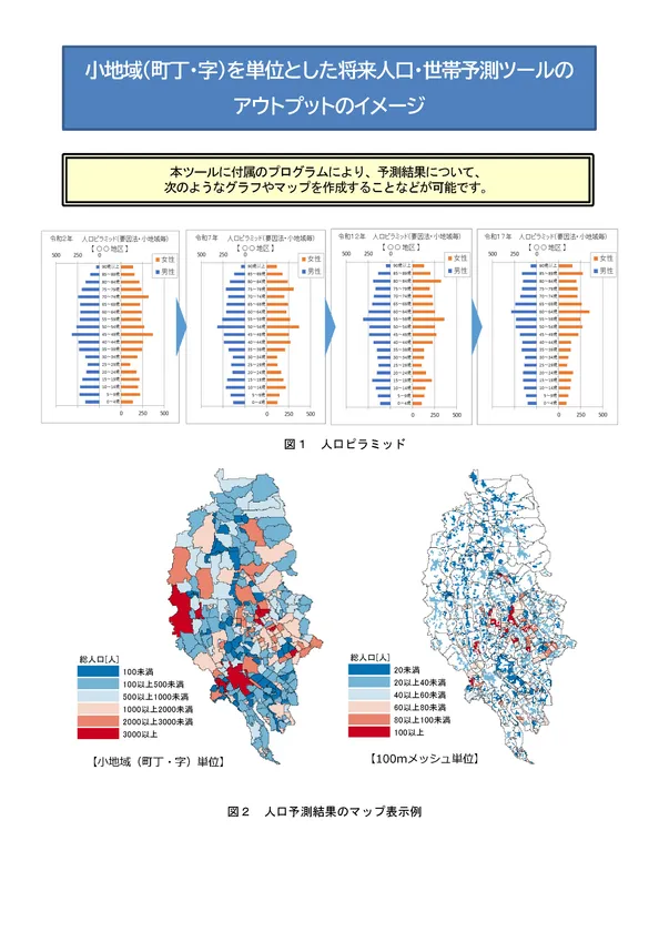
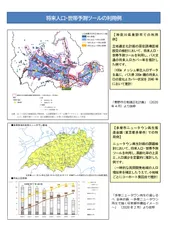
Output image of the future population and household projection tool
■How to obtain this tool
Please register as a user on the portal site "Geospatial Information Center" (https://www.geospatial.jp/) operated by Association for Promotion of Infrastructure Geospatial Information Distribution, and then download this tool from NILIM website (https://www.geospatial.jp/ckan/organization/nilim). It is available for free.
■Organization
Name of Organization: National Institute for Land and Infrastructure Management (NILIM), Ministry of Land, Infrastructure, Transport and Tourism
Representative: Yukihiro Fukuda, Director-General
Location: 1 Asahi, Tsukuba, Ibaraki 305-0804, Japan
Image

Logo Image
- Category:
- Services